How Does GPS Work? A Simple Guide to GPS Technology
GPS has become such a normal part of everyday life that most people rarely stop to think about how it actually works.
You open Google Maps, enter a destination, and within seconds your phone can show where you are, which direction you are moving, and how long it may take to reach your destination.
But how can a device sitting in your hand determine your location without physically measuring where you are?
The answer involves satellites, extremely accurate timing, radio signals, mathematics, and specialized receivers inside modern devices.
Let’s take a simple look at how GPS works and how your smartphone turns signals from space into a location on a map.
1. What Is GPS?
GPS stands for Global Positioning System.
It is a satellite-based navigation system that allows compatible receivers to determine their position by receiving signals from satellites orbiting Earth.
The system was developed by the United States and is now used by billions of devices and applications around the world.
GPS is part of a broader family of global satellite navigation systems. Other countries and regions operate their own systems, including Europe’s Galileo, Russia’s GLONASS, and China’s BeiDou.
Modern smartphones can often use signals from multiple satellite navigation systems to improve positioning.
2. How Do GPS Satellites Help Determine Your Location?
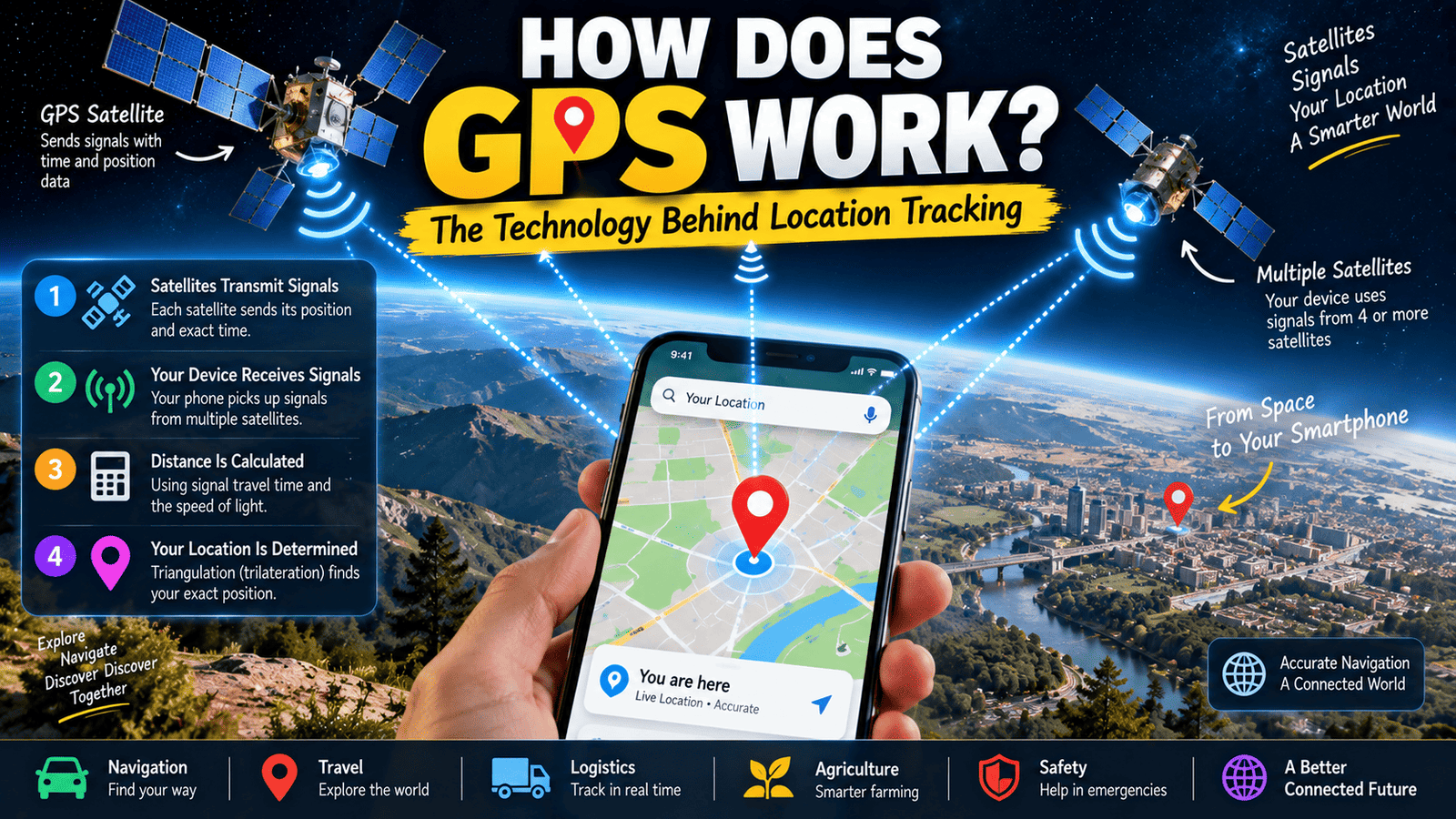
GPS works because satellites continuously transmit signals containing information that allows a receiver to calculate distances from those satellites.
Each satellite has a very precise clock and sends timing information as part of its signal.
Your phone or GPS receiver receives these signals and compares the timing information with the time at which the signals arrived.
Because radio signals travel at a known speed, primarily the speed of light, the receiver can estimate how far away a satellite is.
When information from several satellites is combined, the receiver can calculate its position.
3. Why Does GPS Need More Than One Satellite?
A single satellite cannot normally tell your receiver exactly where it is on Earth.
Imagine knowing that you are exactly 20 kilometers away from a particular point. There could be many possible locations that are 20 kilometers from that point.
A second measurement narrows down the possibilities, and additional measurements make the position much more precise.
GPS receivers therefore use signals from multiple satellites to determine a three-dimensional position and account for timing differences in the receiver’s clock.
4. What Is Trilateration?
The mathematical process behind GPS positioning is often described using the term trilateration.
Trilateration uses distances from known reference points to determine the position of an object.
GPS satellites act as those reference points.
By estimating the distance between the receiver and several satellites, the receiver can determine where those distance measurements intersect.
This is different from triangulation, which traditionally refers to determining a position using angles rather than distances.
5. Why Is Accurate Time So Important for GPS?
Timing is one of the most important parts of GPS.
GPS signals travel extremely quickly. Even a tiny error in measuring the signal’s travel time can produce a significant error in the estimated distance.
That is why GPS satellites carry extremely accurate atomic clocks.
The receiver also needs to keep track of time accurately enough to interpret the incoming signals. Because the receiver’s clock is not as precise as the clocks aboard the satellites, GPS calculations use signals from additional satellites to help correct the receiver’s timing error.
6. How Does Your Phone Know Where You Are?
Your smartphone contains hardware capable of receiving signals from satellite navigation systems.
When location services are enabled, the phone can use these satellite signals along with other sources of information to estimate its position.
Depending on the device and environment, a smartphone may combine satellite positioning with information from Wi-Fi networks, cellular networks, sensors, and other technologies.
This combination can make location services faster and more useful, especially when satellite signals are weak or temporarily unavailable.
7. Does GPS Need Mobile Internet?
GPS itself does not require a mobile internet connection to receive satellite signals.
A GPS receiver can determine a position using satellite signals even when the phone has no cellular data connection.
However, smartphone navigation applications may use an internet connection for other functions, such as downloading maps, receiving traffic information, searching for places, calculating routes, or updating online information.
This distinction is important because GPS positioning and internet-based map services are separate technologies that often work together.
8. Why Can GPS Take Longer to Find Your Location?
Sometimes your phone finds your location almost immediately. At other times, it may take longer.
One reason is the availability and quality of satellite signals.
If you are outside with a relatively clear view of the sky, your device may have an easier time receiving signals from multiple satellites.
Inside buildings, underground parking areas, tunnels, or locations surrounded by tall structures, satellite signals can be weakened or obstructed.
Your phone may then rely more heavily on other location technologies while it continues trying to obtain a strong satellite position.
9. Why Does GPS Work Better Outdoors?
GPS satellites are far above Earth, so having a relatively clear path toward the sky generally makes it easier for a receiver to obtain their signals.
Buildings and other structures can block or reflect signals.
Inside a large building, your phone may have difficulty receiving enough useful satellite signals to calculate a precise position.
That is why location accuracy can sometimes change significantly when you move from an outdoor environment into a building.
10. Why Can Tall Buildings Affect GPS Accuracy?
Cities with many tall buildings can create a difficult environment for satellite navigation.
GPS signals can reflect from buildings before reaching a receiver. These reflected signals can arrive slightly later than the direct signal.
This phenomenon is called multipath.
When a receiver has to deal with reflected signals, the calculated position can become less accurate.
This is one reason your location marker may sometimes appear to jump between nearby streets or show a position slightly different from your actual location in dense urban areas.
11. How Accurate Is GPS?
GPS accuracy depends on many factors, including the quality of the receiver, satellite geometry, atmospheric conditions, signal obstruction, and whether additional positioning technologies are available.
Under good conditions, consumer devices can often determine location within several meters.
However, accuracy is not guaranteed to be exactly the same at every moment or in every environment.
Professional systems can achieve much greater accuracy by using advanced techniques, correction services, and specialized equipment.
12. What Is GPS Used For?
GPS is used for far more than finding directions.
Navigation applications use satellite positioning to help drivers, cyclists, hikers, and pedestrians understand where they are and where they are going.
Transportation companies can use location technology to monitor vehicles and improve logistics.
Emergency services can use location information to help identify the approximate position of people who need assistance, depending on the available systems and circumstances.
GPS is also used in aviation, maritime navigation, agriculture, surveying, scientific research, telecommunications, and many other fields.
13. How Does GPS Help With Driving Directions?
When you use a navigation application while driving, GPS helps the application determine your approximate position and movement.
The application can compare that position with digital map data.
As your vehicle moves, the system repeatedly updates your estimated position.
The application can then show your position on the map, determine whether you are following the planned route, and provide instructions based on the road network.
Traffic information and route recommendations may come from additional online data rather than GPS itself.
14. Why Does GPS Show Your Movement on a Map?
GPS does not actually contain a map of every road.
The receiver primarily provides positioning information.
The navigation application combines that positioning information with digital map databases.
When your device calculates a new position, the software places that position on the digital map and updates it as you move.
This is why GPS and mapping software are closely connected but are not exactly the same thing.
15. Can GPS Work Without a SIM Card?
A device with appropriate satellite positioning hardware can receive GPS signals without a SIM card.
However, what the device can do with that position depends on the software and available data.
For example, an offline navigation application with maps already stored on the device may be able to provide useful navigation without cellular service.
Online services that require an internet connection will naturally have fewer capabilities when the device is offline.
16. Can GPS Work Without Wi-Fi?
Yes, GPS positioning can work without Wi-Fi.
The satellite receiver communicates with GPS satellites directly through radio signals.
Wi-Fi can still help a smartphone determine its approximate location more quickly in certain situations, but it is not required for the basic GPS satellite positioning process.
This is one reason a dedicated GPS device can continue determining its position even when it is not connected to a Wi-Fi network.
17. Does GPS Track You by Itself?
GPS is fundamentally a positioning technology.
A GPS receiver receives signals from satellites and calculates its position. The satellites do not need to receive your phone’s GPS position in order for the basic positioning calculation to work.
However, a smartphone application can collect, store, or transmit location information depending on the app’s permissions, settings, and privacy practices.
Therefore, it is important to distinguish between GPS technology itself and the applications or services that use location information.
18. What Is the Difference Between GPS and Google Maps?
GPS and Google Maps serve different purposes.
GPS is a satellite-based positioning technology that can help determine where a receiver is located.
Google Maps is a mapping and navigation service that uses digital maps and can use location information from GPS and other sources.
When you see the blue location dot on a map, multiple technologies may contribute to that position, while the map itself provides the geographic context around it.
19. Why Does GPS Sometimes Show the Wrong Location?
GPS positioning is an estimate, and several factors can reduce its accuracy.
Weak satellite signals, tall buildings, indoor environments, signal reflections, atmospheric effects, and limited satellite visibility can all contribute to positioning errors.
Smartphone location systems can also temporarily display an inaccurate position when they are combining incomplete or conflicting information from different sources.
In most cases, moving to an area with a clearer view of the sky gives the device a better opportunity to improve its position estimate.
20. How Does GPS Work in Simple Terms?
The simplest way to understand GPS is to imagine your phone listening to several extremely accurate clocks in space.
Each GPS satellite sends a signal containing timing information and information about its position.
Your phone measures how long those signals took to arrive.
Because the signals travel at a known speed, the phone can estimate its distance from each satellite.
By combining measurements from multiple satellites and correcting for timing differences, the receiver calculates its approximate position on Earth.
The navigation application then places that position on a digital map.
21. Why Is GPS Technology So Important?
GPS has changed how people navigate and how many industries operate.
Before satellite navigation became widely available, determining an exact position often required maps, landmarks, specialized instruments, or other forms of navigation.
Today, a small device in your pocket can continuously estimate its location while you travel.
This capability supports navigation, transportation, logistics, agriculture, scientific research, emergency services, and countless everyday applications.
Final Thoughts
GPS may look simple when you see a small blue dot moving across a smartphone map, but the technology behind that dot is remarkably sophisticated.
Satellites, atomic clocks, radio signals, mathematical calculations, digital maps, and smartphone sensors can all work together to create the location experience people use every day.
The next time your phone tells you exactly where you are, remember that it is calculating that position using signals that have traveled from satellites far above Earth.
And just like Wi-Fi, GPS is another example of complex technology quietly working in the background of everyday life.
If you enjoyed learning how everyday technology works, you can also read our guide on how Wi-Fi works and how wireless internet connects your devices.
You can also explore our strange but true facts about the world for more fascinating science and technology-related facts.